


Sentier du facteur

dtag47
User
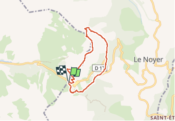

Length
6.2 km

Max alt
1886 m

Uphill gradient
464 m
Km-Effort
12.3 km

Min alt
1430 m

Downhill gradient
463 m
Boucle
Yes
Creation date :
2024-08-04 11:58:34.0
Updated on :
2024-08-04 14:55:52.508
2h36
Difficulty : Difficult

FREE GPS app for hiking
 SityTrail
IGN / Geographical institutes
SityTrail Plus
The world is yours!
About
Trail Walking of 6.2 km to be discovered at Provence-Alpes-Côte d'Azur, Hautes-Alpes, Le Noyer. This trail is proposed by dtag47.
Positioning
Country:
France
Region :
Provence-Alpes-Côte d'Azur
Department/Province :
Hautes-Alpes
Municipality :
Le Noyer
Location:
Unknown
Start:(Dec)
Start:(UTM)
736492 ; 4953097 (31T) N.
Comments